Drones and AI Revolutionize Wildlife Conservation in Botswana
by
AfricaLive Editor
. September 4, 2024
Researchers at the Botswana International University of Science and Technology have developed a groundbreaking approach to wildlife monitoring and anti-poaching efforts, combining drone technology with artificial intelligence (AI).
This innovation comes at a crucial time for Botswana’s wildlife, particularly its rhino populations, which were poached to near-extinction in the 1980s before being reintroduced in 2001. The new technology aims to augment traditional conservation methods and improve the efficiency of wildlife protection efforts.
Key Points:
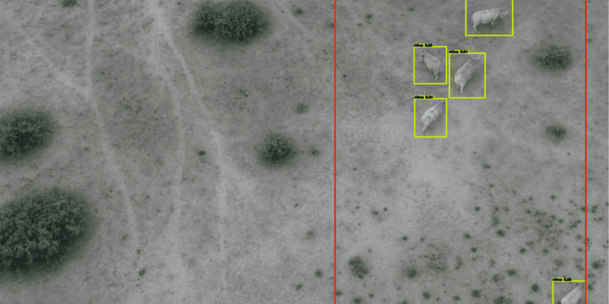
Botswana researchers have developed an AI system that can classify different animal species and detect potential poachers using drone footage. The AI analyzes herd behavior patterns viewed from above, assigning each animal a point and interpreting their movements and interactions, offering a novel approach to wildlife monitoring.
The method has been successfully tested in the Khama Rhino Sanctuary in Botswana, demonstrating its potential for wider application in wildlife conservation efforts across Africa and beyond.
The drone and AI system offers several advantages over traditional wildlife monitoring methods, including consistent data collection, reduced human fatigue, and potentially lower costs compared to helicopter surveys.
While promising, the technology faces implementation challenges including drone height restrictions to avoid disturbing wildlife, permit requirements, and environmental factors such as dense vegetation or sunlight reflection affecting data collection.
This research showcases Africa's growing capacity for technological innovation in conservation, challenging perceptions about the continent's scientific capabilities and positioning African researchers at the forefront of conservation technology.
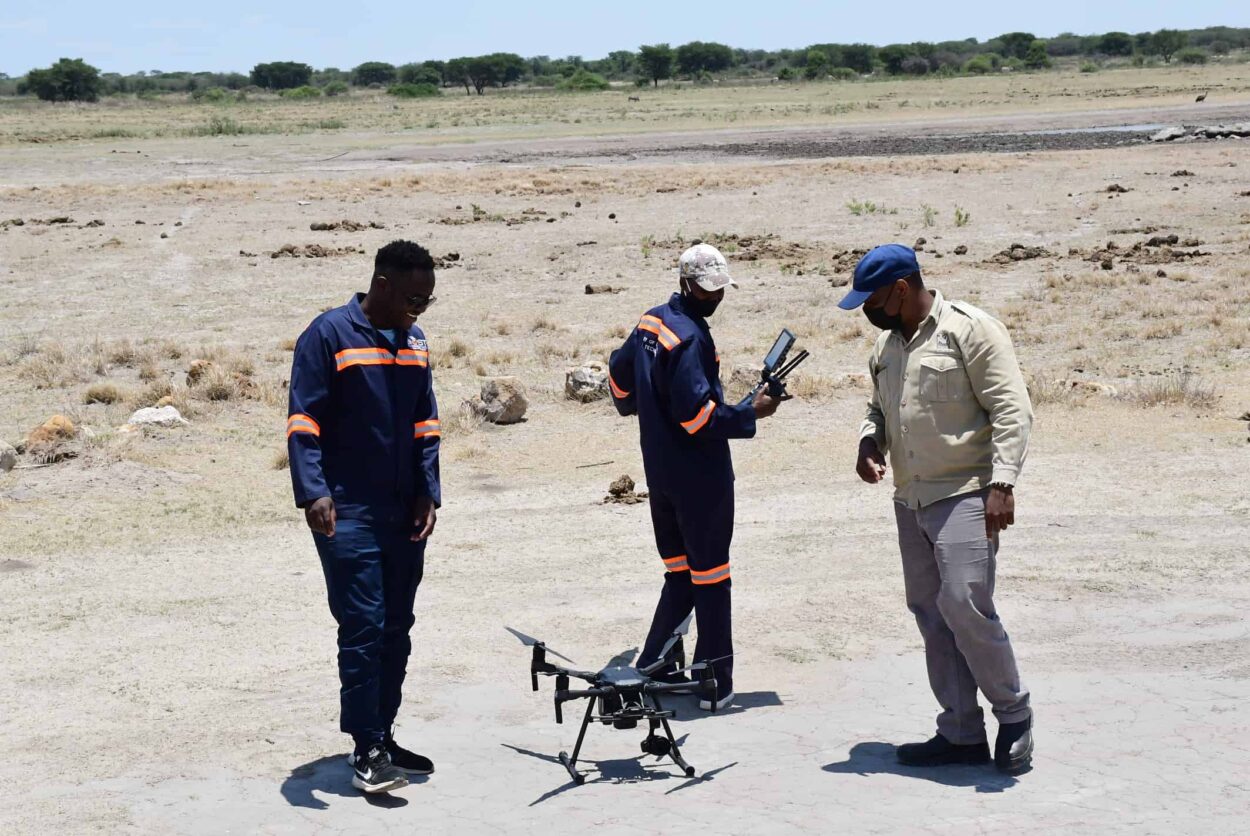
Researchers in Botswana are using new technology—including drones and artificial intelligence—can help monitor wildlife and keep an eye out for possible poachers.
Botswana's Technological Leap in Conservation
Traditionally, wildlife monitoring and anti-poaching efforts in Botswana have relied on round-the-clock foot patrols by soldiers. While dedicated, this method has limitations in terms of coverage and human endurance. Rodrigo Jamisola Jr., an associate professor at the Botswana International University of Science and Technology, explains, “With manual efforts, it can be quite challenging in terms of humans being tired and having only a limited view of what is going on just where we’re standing.”
To address these limitations, Jamisola and his team have developed a system that combines drone technology with artificial intelligence. This approach provides a wider field of view and constant monitoring capabilities, potentially revolutionizing wildlife conservation efforts.
AI That Understands Herd Behavior
The research team’s approach to species identification sets their work apart. Rather than training computers to recognize individual animal characteristics, they focused on herd behavior patterns viewed from above.
Tinao Petso, a Ph.D. student leading the study, describes their method: “We assigned each animal a point and trained the computer to recognize how these different points move and interact.” This innovative approach allows the AI to not only classify herds as zebras, giraffes, or elephants but also to distinguish between patrolling soldiers and potential poachers based on their movement patterns.
The results, published in Science Robotics, show that the system has successfully classified various species and human activities in tests conducted at the Khama Rhino Sanctuary in Botswana.
Drones vs. Traditional Surveys: A New Era of Monitoring
The potential of drones in wildlife surveys extends beyond Botswana. Research from South Texas, published in the Wildlife Society Bulletin, offers valuable insights that complement the Botswana study.
Aaron Foley, an assistant professor with the East Foundation and the Caesar Kleberg Wildlife Research Institute, found that drone surveys can be as accurate as helicopter counts for estimating white-tailed deer populations. Moreover, drone surveys proved more consistent in their estimates.
“We wanted to evaluate whether drones could generate more consistent population estimates,” Foley states. His research suggests that drones, when used correctly, can indeed provide reliable data while offering advantages in terms of cost and safety over traditional aerial surveys.
Challenges and Future Directions
Despite the promising results, challenges remain in implementing this technology. Jamisola notes that researchers must consider minimum heights where drones can operate without disturbing wildlife. Additionally, drone use in wildlife areas requires permits, limiting spontaneous deployment.
Environmental factors also play a role in the technology’s effectiveness. Dense brush can obscure animals from view, while sunlight reflection in open areas can interfere with thermal imaging. As Foley’s research shows, “some environments are more amenable to drone surveys compared to others.”
However, these challenges are not insurmountable. As technology advances and researchers refine their methods, the accuracy and applicability of drone and AI systems in wildlife monitoring are likely to improve.
Africa at the Forefront of Conservation Technology
This research represents more than just a local success story; it demonstrates Africa’s growing role in developing cutting-edge conservation technology. Jamisola acknowledges the challenges faced by African researchers: “There’s some sort of a stigma of researchers in Africa. It can be quite challenging in terms of making people believe we have some good research.”
Yet, this work proves that Africa is not just catching up – it’s leading the way in applying advanced technology to pressing conservation challenges. The continent’s unique wildlife and vast landscapes provide the perfect testing ground for innovations that could have global implications.
As Africa continues to develop its technological capabilities, research like this serves as a powerful reminder of the continent’s potential to contribute to global scientific advancement while addressing its unique environmental challenges. The fusion of drones, AI, and wildlife conservation in Botswana may well become a key tool in the global fight to protect endangered species and preserve biodiversity.
Challenges include minimum height restrictions to avoid disturbing wildlife, the need for permits, and environmental factors like dense vegetation or sunlight reflection interfering with thermal imaging.
Research suggests that drone surveys can provide population estimates similar to helicopter surveys, with the added benefits of being more consistent, safer, and potentially more cost-effective.